Wednesday, March 30, 2011
Bellaire Bridge saga
In this week's State Journal, I have a piece about the legal fight that has delayed the demolition of the old Bellaire Bridge near Wheeling.
Tuesday, March 29, 2011
Penny Eckstein
This morning, before I got Adam up for school, I clicked on Dick's Towboat Gallery, and what was on the home page but a photo of the towboat Penny Eckstein.
I enjoyed looking at the pictures on the site for a couple of reasons. One was that I found some slides of this boat that I had gotten in the late 1980s when it was the Angel Brooke. I didn't scan any of them, though. The photos weren't that great, but I do have a bit of a photographic record of it being on the Ohio River back then.
The main reason I liked finding a picture of the Eckstein is that it reminded me that in my young days, this style of boat was what I thought of when the word "towboat" came up. The lines of the design, the sound of the engines ... back in the late 1960s, this is what a "towboat" was to me.
Now most of them are in South America. But I do like seeing the Pennsylvania and the Ronald E. Wagenblast when they're in my area and I can get down to the river.
Sunday, March 27, 2011
the Kentucky
Today Adam and I got to see the new Marathon Petroleum Co. towboat Kentucky actually moving on the Ohio River. The other times we've seen it, it's been tied to shore off in the distance. But today we got to se it close up.


Here the Kentucky is seen from a small picnic shelter at the upper end of Pomeroy, Ohio.

Here it's about to pass under the Bridge of Honor between Pomeroy, Ohio, and Mason, W.Va. In the lower right corner is one of the lights that turns the bridge purple at night.

And here's a closer look at the boat.

As seen from Tu-Endie-Wei Park in Point Pleasant, W.Va., with Kanauga, Ohio, in the background. Here the boat is at the spot where the Silver Bridge once stood.

Exiting the Robert C. Byrd Locks and Dam.

And heading down the Ohio River toward its home dock at Catlettsburg, Ky,

News nuggets
Many coal-fired power plants along the Ohio River have cooling towers to lower the temperature of water before it is returned to the river. Some don't. One of those is the Stuart generation station in Ohio at f about Mile 404. The question is whether the water that's being discharged into the river is too hot for wildlife and for human health, too. A public hearing was conducted on that last week, with comments from both points of view.
###
The Cave-In-Rock ferry is back in business now that the river is going down and the ramps have been cleaned. If I can ever scrape together the money and the time, I'm going back down that way, and crossing the river on the ferry will be high on my to-do list.
###
The West Virginia Division of Natural Resources wants to change its bass fishing regulations for the Ohio River to make them consistent with Ohio's, thus reducing confusion for people who fish in the river. The DNR is proposing a 12-inch minimum.
###
Finally, Adam and I went to Virginia Point Park at Kenova, W.Va., Friday evening to see what we could see. There were no boats running in the area save for a line haul boat far, far down the river heading away from us. But we did see two backhoes running, clearing mud off the parking lot at the boat ramp there. I went to another boat ramp Saturday evening, but it was still covered in mud.
Some people don't mind driving in that mud. I made that mistake once. First, when you have a layer of mud on asphalt, it's as slick as ice. Second, the mud gets up in your wheelwells, and it's a pain to clean out.
So I'l not play in the mud for now.
###
The Cave-In-Rock ferry is back in business now that the river is going down and the ramps have been cleaned. If I can ever scrape together the money and the time, I'm going back down that way, and crossing the river on the ferry will be high on my to-do list.
###
The West Virginia Division of Natural Resources wants to change its bass fishing regulations for the Ohio River to make them consistent with Ohio's, thus reducing confusion for people who fish in the river. The DNR is proposing a 12-inch minimum.
###
Finally, Adam and I went to Virginia Point Park at Kenova, W.Va., Friday evening to see what we could see. There were no boats running in the area save for a line haul boat far, far down the river heading away from us. But we did see two backhoes running, clearing mud off the parking lot at the boat ramp there. I went to another boat ramp Saturday evening, but it was still covered in mud.
Some people don't mind driving in that mud. I made that mistake once. First, when you have a layer of mud on asphalt, it's as slick as ice. Second, the mud gets up in your wheelwells, and it's a pain to clean out.
So I'l not play in the mud for now.
Saturday, March 26, 2011
Tobacco market gone
I was in a residential neighborhood of Huntington today, so I thought I would swing by and see what the old Huntington Pride in Tobacco Market looked like nowadays. That was where farmers from a wide area around brought their burley tobacco in the fall to be auctioned to tobacco companies. Burley is one of three varieties of tobacco that are blended to make cigarettes, and many country folk relied on the area's main cash crop to get them through the winter, to buy groceries or maybe make a large purchase.
Seeing tobacco grow in patches along the river road was a common sight up into the 1980s and 1990s.

In my daily newspaper reporter years, I would call the manager of the Huntington market after each weekly or semiweekly auction and get the numbers: amount sold, high price, average price, number of checks written to farmers, that sort of stuff. The market closed several years ago as burley production declined.
So I went by there today out of curiosity to see what use the old building was being put to. What I saw was a vacant lot with fresh dirt and a couple of pieces of idle earthmoving equipment. So I guess someone needs the spot, and the old building just didn't fit the bill.
And another piece of my past disappears. I know this sort of creative destruction is a part of life, but watching your past erode away like that brings on memories. There was the time on a Thanksgiving day back in the 1960s when I went down there with my father in his blue 1964 Dodge flareside pickup to offload some tobacco. The FFA at my high school raised tobacco as its major fundraising project for the year.
Oh well, that's past. I guess tobacco farmers around here to go Morehead, Ky., or Ripley, Ohio, now.
The photo above was taken along Ohio State Route 7 in the late 1980s. I believe that's the Valvoline when it was owned by Ashland Oil. Note the stack emblem and the Ashland logo below the pilothouse.
Radioactive pollution in the Ohio?
With what's going on in Japan, it should be noted that a labor dispute at Metropolis, Ill., has come to the point that workers say radioactive mud is leaking into the Ohio River, although the EPA does not confirm this.
Kayaking down the Ohio
A fellow named Brett Ciccotelli is kayaking down the Monongahela, Ohio and Mississippi rivers from about 25 miles above Pittsburgh to New Orleans. His stated purpose is "to document the impact of energy, in particular coal, on that watershed and its communities."
His most recent entry as of this morning have him on the Ohio at about Mile 46. You can read his travels here.
And he's posting photos he takes on his Flickr photostream.
His most recent entry as of this morning have him on the Ohio at about Mile 46. You can read his travels here.
And he's posting photos he takes on his Flickr photostream.
Tuesday, March 22, 2011
Old photo
Here's an old photo with a pilot's-eye view of going through one of the old locks on the Ohio River near Huntington. The photo caption says this is old Lock 28, but I'd say it was Lock 27.
When you click on the link, look at the grid of photos beside the big one, which is a Marshall football game. It's the fourth one down on the left side. Click on it to see the picture.
When you click on the link, look at the grid of photos beside the big one, which is a Marshall football game. It's the fourth one down on the left side. Click on it to see the picture.
The Detroit and the Hoosier State
Here are some pics I got this past weekend of the Detroit passing Cheshire, Ohio ...


... That's Lakin, W.Va., in the background.
And here's the Hoosier State on the bank of the Kanawha River at Point Pleasant, W.Va., as seen from Henderson.


Trees are in the way because what high water didn't cover at my normal shooting spot, thick, gooey mud did.


... That's Lakin, W.Va., in the background.
And here's the Hoosier State on the bank of the Kanawha River at Point Pleasant, W.Va., as seen from Henderson.


Trees are in the way because what high water didn't cover at my normal shooting spot, thick, gooey mud did.
Monday, March 21, 2011
Two rivers, two Vikings
The R.L. Carter Jr. had backed out of the Kanawha River by the time I got there on Sunday ....

... after which it proceeded up the Ohio River with its tow.

While the R.L. Carter Jr. was doing that, the Capt. John Reynolds was over at Amherst harbor for a little while.

By the time the R.L. Carter Jr. had passed out of my sight, the Capt. John Reynolds had left Amherst for a point somewhere up the Kanawha.
M/V or mv. ?
An old-timer doesn't like how I abbreviate "motor vessel" as "mv." He would prefer I use the method "M/V" ...
Which should it be? I reserve the final decision, of course, but if anyone out there has an opinion to share, I'd like to hear it.
Which should it be? I reserve the final decision, of course, but if anyone out there has an opinion to share, I'd like to hear it.
mv. Floyd H. Blaske at Point Pleasant
While I was in Point Pleasant yesterday, I got to see the mv. Floyd H. Blaske of Inland Marine come out of the Kanawha River with nine empties and head down the Ohio River.


I saw the boat a few hours later moving along pretty good. I don't think the pilot was letting any moss grow on his propeller, to borrow a phrase someone once used about my driving habits in my first VW Scirocco.


I saw the boat a few hours later moving along pretty good. I don't think the pilot was letting any moss grow on his propeller, to borrow a phrase someone once used about my driving habits in my first VW Scirocco.
Sunday, March 20, 2011
mv. Ocie Clark
Sometimes there are boats on the Ohio River that don't stand out. They're not noticeably new or old. They don't have an unusual design. But they're still there, doing a lot of the work that needs to be done.
Among them is the mv. Ocie Clark of Ingram Barge Co. I've seen it a few times, but I never paid a whole lot of attention to it. Well, I saw it yesterday and decided to give it some of my time and pixels.
The Ocie Clark is older than I thought it was. It was built by St. Louis Ship in 1965. It's 154 feet long and 40 feet wide. Its engines generate 4,800 horsepower.
I don't know why I hardly noticed it on the Ohio River until a year or two ago. Maybe it wasn't there. Maybe I was looking for other boats.
Anyway, here are a few pictures of the Ocie Clark that I got yesterday from Henderson, W.Va.
First, the Ocie Clark is running lightboat, having come down the Ohio from a dock a few miles to the north. It's making the turn to enter the Kanawha.


And here it passes under the Bartow Jones Bridge over the Kanawha, with Point Pleasant in the background.

News roundup 3/30/11
I must have not been paying attention the past decade or so. Posters for the 11th annual Ohio River Way Paddlefest are for sale. As described by cincinnati.com, Paddlefest is "the largest annual canoe/kayak paddling event in the Midwest, involving more than 2,000 paddling their way down the Ohio River." This year's event is June 23-25. It sounds like something I'd like to see. ...
This question comes up ever so often, and now it's being faced on the Allegheny River. At what point do the locks and dams on the smaller tributaries of the Ohio River become too expensive to operate and maintain, considering their age and traffic levels? ...
Did you know that the world's first commercial nuclear facility dedicated solely to generating electricity went into operation on the banks of the Ohio River more than 50 years ago? I didn't either. ...
Officials in Indiana and Illinois are debating the justification -- economic and otherwise -- of building plants to make natural gas from coal. One of the proposed plants is a $2.65 billion project along the Ohio River at Rockport, Ind. ...
Oh. Spring officially begins this evening around or shortly after suppertime, I'm told. Hooray. Now if we can just get the river to go down and the banks to dry out.
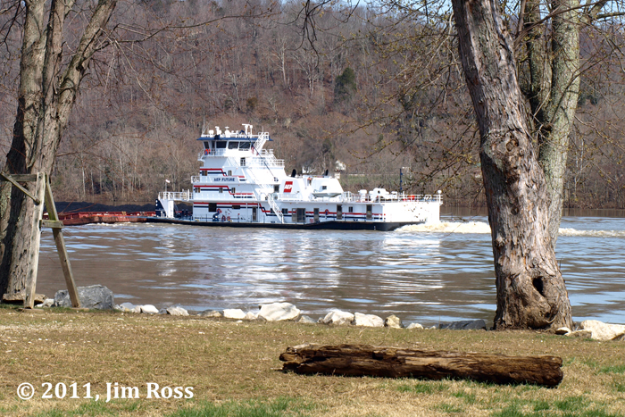
Saturday, March 19, 2011
mv. AEP Future
Adam and I saw AEP's newest towboat today.
Passing Catlettsburg, Ky., with docks of the old Allied Chemical fertilizer plant (I think) at South Point, Ohio, behind it.

Seen from Virginia Point Park in Kenova, W.Va. The barges in the foreground are tied to the bank.

Seen from a residential street a few hours later in Athalia, Ohio.

And a final shot at a spot I found today. This will be a good shooting location in late afternoon when the hills are green again.

To come are photos of the Ocie Clark, the Detroit, the Hoosier State and maybe the Oliver C. Shearer.
Passing Catlettsburg, Ky., with docks of the old Allied Chemical fertilizer plant (I think) at South Point, Ohio, behind it.

Seen from Virginia Point Park in Kenova, W.Va. The barges in the foreground are tied to the bank.

Seen from a residential street a few hours later in Athalia, Ohio.
And a final shot at a spot I found today. This will be a good shooting location in late afternoon when the hills are green again.

To come are photos of the Ocie Clark, the Detroit, the Hoosier State and maybe the Oliver C. Shearer.
Lots of boats today
It must be because the Ohio River is going down instead of up, but we saw a lot of boats today.
We saw the AEP Future at Kenova, W.Va. We also saw the Hoosier State at Point Pleasant, and I got the Detroit at Cheshire. And the Ocie Clark lightboat at Point Pleasant. Adam shot the Oliver C. Shearer through my open car window, and we saw the Lelia C. Shearer (we think) at a distance, but no photo. We saw the D.A. Grimm lightboat running from Henderson up to the dock at about Mile 263; no photo. I saw the Ocie Clark there, too, before I saw it at Point. After weeks of slim pickings, we saw a lot of them today.
Photos coming later.
Friday, March 18, 2011
The (AEP) Future is tomorrow
It looks like Adam and I will be out chasing one of AEP's newest towboats, the AEP Future, tomorrow or Sunday. It's in the Meldahl pool upbound, so it should be in our area this weekend.
We haven't seen the boat yet, so we'll have to shoot it (photographically, of course). These are not good conditions for shooting -- the river is muddy, the trees are bare, the light looks like summer but the landscape looks like winter -- but we'll do it anyway.
A week or two ago, the Ingram towboat Omar, which I haven't seen in maybe 20 years, was close to where I live, but it got here at a time and date that were bad for me, then it turned and headed back downriver. Maybe next time.
Gallipolis, Ohio, in the New York Times
The New York Times parachutes in to Gallipolis, Ohio, and does a story. I'm familiar with the town. This weekend, I'll dissect the story, because it touches on a lot of things that have changed -- some that probably are not familiar to media paratroopers.
Sunday, March 13, 2011
Flood Sunday
Today I drove up to Glenwood, W.Va., on State Route 2. It's the lowest community along the Ohio River in the part I call home, meaning it's the first to flood when the river comes up.
Once there, I realized that I've photographing and writing about floods since 1978, but I had never been to the place that always floods first. And lately I've been thinking about Glenwood more. I hear that my great-grandfather ran a ferry between Glenwood and Swan Creek, Ohio. And another of my ancestors was building a barn in the Glenwood area at the time of his death. He got drunk in Gallipolis, Ohio, on a Saturday night, laid down beside the railroad tracks and was struck by a passing train. The obituary said he was clever and industrious when sober, but was addicted to drink. I guess his ex-wife helped write it.
Anyway, at the lower end of Glenwood was this RV sitting in water.

Here is the scene looking upriver. That's Trippett's Dandi Mart, a long-time locally owned convenience store in the water on the left.

People asked Milton Trippett if he was trying to clear a drain. No, he said, he was stirring up the mud. If he didn't, it would harden when the river goes down and be very hard to remove, he said.

The double yellow line of Route 2 runs off into the water.

And someone gets the family photo of the flood.

Looking back downriver, the water is starting to recede, as evidenced by the location of trash and vegetative matter on the road.

The mv. Andrew Canava heads down the river. This was taken while I was standing on Route 2, so the river it still almost at road level.

This was the third downbound towboat I'd seen in the space of about an hour, and at least two of the three were making good time, helped along by the current.
And that's about it for my flood photography for this event, I guess. Monday awaits, as always.
Too tall
Sometime this weekend, Adam put this status update on his Facebook page: "I did the math, and the river is about 5 barges deep"
Today, Joe Kincaid, a pilot on the AEP boat Hoosier State, left this comment: "You definitely don't have to worry about running aground any were near the middle of the river right now. You do however have to concerned with everything else. We can't even fit under the RR bridge at Point Pleasant. That's with everything laid down on top of the wheelhouse too."
Flood Saturday, Part 3
Final three pics from Saturday's trip up the Ohio River. Probably.
I saw a lot of this along Ohio Route 7.

One farmer saved as much as he could, but it looked like the river got more than half of it.
Here's the view from Mound Hill Cemetery at Gallipolis, Ohio. The bottomland over in West Virginia wasn't as flooded as I thought it would be.

At one time, I saw a boat off in the distance, pushing some barges up the river. Its engines were putting out a lot of smoke.
For the trip back to Huntington, I decided to try West Virginia Route 2 south of Point Pleasant. I got about eight miles, then I found the water over the bridge at Crab Creek. I shot this through my windshield and into the sun. I didn't get out of the car. If you look in the lower left corner, you'll see a Dodge Durango turning around. There was a lot of that, and I didn't want to stand in traffic.

I didn't want to drive through this. Even if my car could have made it -- which I doubt -- there was too great a chance for damage. So I went back down the Ohio side.
There's one other spot I want to shoot. I might try to get to it today.
Flood Saturday, Part 2
Here is the mv. Midland, slowly moving toward the main lock at the Robert C. Byrd Locks and Dam so it can continue up the Ohio River. Boats were moving very slow this day at some places. On the way up the river, I saw one boat chugging along, then it began drifting backward before it started moving forward again upbound.

If you look at the Midland, you can see the road along the top of the bank running behind the boat's nameboard beneath the pilothouse. In normal pool, the top of the boat is well below the road.
And here is the riverward guidewall at R.C. Byrd. Normally it's out of the water 30 feet or more. Here it looks like the water is about to top it.

Because of the position of the sun at this time of day and the almost cloudless sky, the lighting here was not the best.
And the rollers of the dam are out of the water, of course.

Another sign advising people to turn around. If you look behind the sign, you may see a pile of trash and drift in the water. That's where the bridge over Teens Run is. It looks like that stuff is accumulating there and will have to be removed somehow or other.

Do you see a cardboard sign attached to road sign with duct tape?

My guess is that someone was trying to be helpful, or someone was tired of being asked for directions.
(To be continued).
Saturday, March 12, 2011
Flood Saturday, Part 1
I got several decent flood-related photos on a trip up the Ohio River from Huntington, W.Va., to Gallipolis, Ohio, and back. I knew where water would be over the road, as I have driven that route in floods many times before.
Adam stayed home this time. He needed his sleep.
First, this is Ohio Route 7 right below Athalia. You can see the road is banked, so part is in deep water but the rest is shallow enough to drive through if you're careful.

The water was not as deep as I've had to drive through in city streets, but it was different. You could see something like a current in it. The low area to the right of the road was out of the water until shortly before I got there. When you looked closely, you could see the water pouring off the roadway and into that low area.
Here in Athalia is that photo of a "High Water" sign partly in the water. My duty is done for the day.

Above Crown City, you can see the river lapping the edges of the road.

And here at the mouth of Swan Creek the water covers half of the road.

When I got up near the Robert C. Byrd Locks and Dam, I saw three boats waiting to lock through. But the angle was so weird. With the water so high, you could stand beside the road and it was almost like you were on the river bank. I guess for a few days, when you stand beside the road, you are on the river bank.

For the record, the boat on the right is the Marge McFarlin. Beside it is the Martha Mac. In the distance is the Midland. More on the Robert C. Byrd Locks and Dam tomorrow.
One more thing: Someone Adam and I knows might be stuck on a towboat for a few days. He was scheduled to get off a couple of days ago, but apparently the company either had no place to put him off or it couldn't get his replacement to the boat.
Another thing: As I drove up the river, I noticed that several large objects on the banks are submerged. I guess that means pilots have to be careful that they don't get too close to shore.
If anyone who works on the river wants to write a short note about what it's like out there right now, I'd be glad to consider posting it.
(To be continued).
Adam stayed home this time. He needed his sleep.
First, this is Ohio Route 7 right below Athalia. You can see the road is banked, so part is in deep water but the rest is shallow enough to drive through if you're careful.

The water was not as deep as I've had to drive through in city streets, but it was different. You could see something like a current in it. The low area to the right of the road was out of the water until shortly before I got there. When you looked closely, you could see the water pouring off the roadway and into that low area.
Here in Athalia is that photo of a "High Water" sign partly in the water. My duty is done for the day.

Above Crown City, you can see the river lapping the edges of the road.

And here at the mouth of Swan Creek the water covers half of the road.

When I got up near the Robert C. Byrd Locks and Dam, I saw three boats waiting to lock through. But the angle was so weird. With the water so high, you could stand beside the road and it was almost like you were on the river bank. I guess for a few days, when you stand beside the road, you are on the river bank.

For the record, the boat on the right is the Marge McFarlin. Beside it is the Martha Mac. In the distance is the Midland. More on the Robert C. Byrd Locks and Dam tomorrow.
One more thing: Someone Adam and I knows might be stuck on a towboat for a few days. He was scheduled to get off a couple of days ago, but apparently the company either had no place to put him off or it couldn't get his replacement to the boat.
Another thing: As I drove up the river, I noticed that several large objects on the banks are submerged. I guess that means pilots have to be careful that they don't get too close to shore.
If anyone who works on the river wants to write a short note about what it's like out there right now, I'd be glad to consider posting it.
Flood Friday
Here are some images from when Adam and I drove around the Tri-State area Friday evening looking at the high water.
First, Section 12, Paragraph 3 of the Unwritten Rules for Photojournalism require us, when possible, to get a photo of a "High Water" sign that is in the water. Editors find them humorous.

You will probably see another example of this on Flood Saturday, to be posted later this evening or early tomorrow.
Here, as seen from South Point, Ohio, is Boggs Landing at Catlettsburg, Ky. This part of Catlettsburg is outside the floodwall. The boats and barges here are almost at street level. The Ingram boat in the front of this pack is the mv. Midland.

You might see the Midland again on Flood Saturday.
What's a flood without some trash washing up on shore? This is the access road to the boat ramp at South Point. As you can see, most of the trash is composed of beverage bottles that people could have tossed into a trash can instead of into the water, but didn't.

Now for three photos that I could have gotten without the high water. First is the mv. Smitty, heading downstream past South Point, with the flooded Virginia Point Park in Kenova, W.Va., in the background.

I had to get a shot of the Detroit, even if those overhead utility lines got in the way.

And here is the Norfolk Southern Railway bridge over the Ohio River between Kenova and South Point, lit up by the evening sun.

As you might have guessed, Flood Saturday is coming. I have several photos to edit for it while I also do some laundry and other housework.
Subscribe to:
Posts (Atom)